Geographic Information Systems (GIS) are used today to create maps. There are two primary types of spatial data, raster and vector. Raster data is spatial data made up of pixels arranged in rows and columns. Every pixel depicts a specific geographic location, and every pixel’s value denotes an attribute of that location. Vector data uses points, lines, and polygons to represent spatial information as opposed to the grids and pixels found in raster data. Geographic data gathered from various sources is presented in disparate formats. However, regardless of how sophisticated your GIS system is, things get complicated. Data conversion services can assist you in converting one data format to another, eliminating the need for you to worry about data consistency and quality ever again. These services offer Vector to Raster conversion, Raster to vector conversion, CAD to GIS conversion and GIS to AutoCAD conversion.
What Is GIS Data Conversion and Why Is It Important?
Encoding a geographic format into a file is known as GIS data conversion. When converting basic raster images to vector models for mapping purposes, GIS data conversion solutions are frequently utilized. The process of converting GIS data into understandable quality data is essential for efficiently conveying spatial information. It is a crucial step in the information transfer process from old databases to new ones, which frequently calls for formatting modifications. Businesses can ensure that GIS data is compatible with their systems by converting into different formats using a variety of strategies.
Precise and strikingly beautiful depictions of GIS data are crucial when making maps, posters, or visuals. In the topographic and GIS industries, they enable insightful conversations regarding geospatial observations and patterns. Industries such as telecom, oil and gas, real estate, etc. frequently outsource GIS data conversion to convert hard copy into digital GIS format.
GIS Data Conversion Strategies
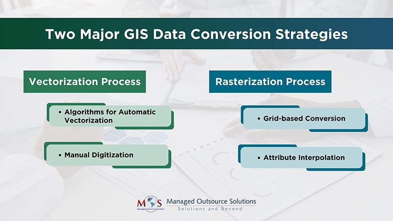
Vectorization Process
The process of vectorization entails transforming raster data usually found in scanned maps or satellite photos into vector format. Vector data is better suited for spatial analysis and visualization because it uses points, lines, and polygons to represent features.
- Algorithms for Automatic Vectorization: It is possible to identify and transform raster features into vector representations using automatic vectorization algorithms, which are provided by many GIS software tools. These algorithms identify boundaries and extract features by applying edge detection and pattern recognition techniques.
- Manual Digitization: When accuracy is essential, this method is utilized. With digitizing tablets or software tools, GIS specialists manually trace features to ensure precise capture of minute details.
Rasterization Process
Rasterization involves converting vector data into raster format. This process is essential for integrating vector data into raster-based analysis or cartographic applications.
- Grid-based Conversion: Vector features are divided into grids, and each grid cell is assigned a value based on the presence or absence of features. This strategy simplifies the conversion process and facilitates raster data analysis.
- Attribute Interpolation: During rasterization, attributes of vector features (such as elevation or population density) can be interpolated to assign values to raster cells. This strategy helps maintain data continuity across the raster dataset.
Although there are different strategies for vectorization and rasterization, it comes with some challenges like loss of details, time-consuming manual digitization process, misinterpretation of data, loss of precision, difficulty in managing and processing larger raster datasets etc. However, these shortcomings can be rectified with the help of a data conversion provider.
Overcoming GIS Data Conversion Challenges with Data Conversion Providers
In order to overcome the difficulties involved in the vectorization and rasterization processes, GIS data conversion services are essential. These services guarantee the precise and effective transformation of spatial data by utilizing cutting-edge technologies, knowledge, and tactical methods.
- Interoperability and Data Integration: Companies frequently work with data in a variety of formats and from a variety of sources. In order to ensure interoperability across various systems and applications, GIS data conversion solutions can integrate and convert data from various formats (such as CAD, shapefiles, and satellite imagery) into a standardized GIS format.
- Scalability: Enterprises might face variations in the amount of data they handle or deal with in projects of different sizes. Large datasets can be handled by GIS data conversion services with ease, enabling businesses to adjust to shifting data needs without sacrificing timeliness or quality.
- Effective Resource Utilization: Businesses can concentrate on their core competencies by contracting out the conversion of GIS data to specialized services. This removes the need for companies to spend money on specialized hardware, software, and trained workers, which saves money and improves operational effectiveness.
- Quicker Reaction Times: When compared to in-house conversion efforts, GIS data conversion vendors are frequently offer faster turnaround times thanks to their specialized tools and expertise. Businesses that need to quickly access converted GIS data or have projects that are time-sensitive will find this to be especially helpful.
- Advanced Technology Access: To handle complicated conversion processes, GIS data conversion solutions are provided using the newest tools and technology, such as sophisticated software and algorithms. As a result, companies can use cutting-edge technology without having to make sizable upfront investments.
Convert your raster and vector data into the desired format with our data conversion services.
GIS data conversion services are essential for resolving issues arising from the vectorization and rasterization procedures. By combining advanced algorithms, customization, quality control measures, and ongoing support, these services ensure that the converted GIS data meets the highest standards of accuracy, precision, and usability for various applications. From ensuring data accuracy to providing scalable solutions, these services contribute to improved decision-making, operational efficiency, and overall business success.