Imagine you have access to a vast amount of geospatial data but struggle to use it effectively because it’s in multiple formats or incompatible with your GIS software. That’s a common challenge organizations face when working with geographic information systems (GIS). This is where GIS data conversion plays a vital role. Whether you’re in urban planning, logistics, agriculture, or environmental management, the ability to convert, integrate, and analyze geospatial data is crucial for making informed decisions. Geospatial data processing services can transform complex geospatial datasets into usable insights for better planning and strategy.
The Power of GIS Data Conversion
A GIS (Geographic Information System) consists of technologies that store, manage, analyze and visualize spatial data for various applications. However, GIS data can be stored in many different file types or digital formats. Each format may be created by different software or used for specific purposes. Because of this dissimilarity, it can be difficult to integrate, compare or map the data. Efficient GIS data conversion for mapping solutions transforms GIS data from one format, structure, or coordinate system into another allows it to be used effectively across different mapping software or applications.
Key Benefits of GIS Data Conversion
- Enhanced Data Accuracy: Converting GIS data helps eliminate inconsistencies, errors, and redundancies, ensuring that organizations work with high-quality, precise data for their projects.
- Seamless Integration Across Platforms: Many organizations use GIS data across different software and platforms. Spatial data conversion solutions ensure compatibility and easy integration with GIS applications, CAD systems, and cloud-based databases.
- Improved Decision-Making: Reliable GIS data empowers businesses, government agencies, and researchers to make informed decisions in urban planning, disaster management, and resource allocation.
- Cost and Time Efficiency: Automating GIS data conversion saves time and reduces labor costs associated with manual data entry and verification.
Before GIS data can be converted, it must first be digitized.
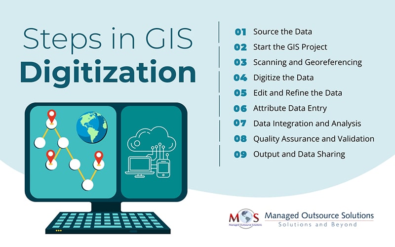
Steps in GIS Digitization
Making maps, analyzing spatial data, and efficiently managing geographic information all require digitizing data in Geographic Information Systems (GIS). Digitization is the process of creating digital data from analog sources. The general procedure for digitizing data in a GIS is as follows:
- Source the Data: Gathering the geographic data you plan to digitize is the first step. Numerous sources provide this information, including satellite imagery, aerial photos, pre-existing maps, GPS data, and field surveys.
- Start the GIS Project: Begin by creating a new project in your GIS software. This involves setting the scale, specifying the coordinate system, and making sure that every data layer will line up properly during the digitization process.
- Scanning and Georeferencing: For physical maps or non-digital images, scanning them into a digital format is necessary. After scanning, the images must be georeferenced, meaning they are assigned spatial coordinates to accurately match real-world locations. This step ensures that all digitized features correspond to their correct positions on the earth’s surface.
- Digitize the Data: Digitization transforms raw geospatial data into structured digital formats, allowing for precise spatial analysis. This process can be done in two ways:
- Manual Digitization – GIS tools allow users to trace map features manually using a mouse or stylus. Roads, rivers, and boundaries are converted into vector data formats such as points, lines, or polygons.
- Automatic Digitization (Vectorization) – Advanced GIS software can automatically convert raster images into vector data by detecting colors, intensities, and patterns. However, this method often requires additional adjustments to improve accuracy.
- Edit and Refine the Data: After digitization, the data must be cleaned and refined. This includes correcting digitization errors, removing duplicate features, snapping misaligned elements, and ensuring proper topological relationships between map layers.
- Attribute Data Entry: Since attribute data gives details about the features of the map, adding it is essential. This could comprise numerical figures, names, descriptions, or classifications. Database imports or manual entry of attribute data are both possible.
- Data Integration and Analysis: For thorough analysis and interpretation, the newly digitized vector layers can be combined with other geographic data layers. Decision-making based on a variety of data sources, modeling, and spatial analysis are made possible with this integration.
- Quality Assurance and Validation: Ensuring the accuracy of digitized data is critical. This step involves cross-referencing the data with control points, verifying against reliable sources, performing statistical accuracy checks, and, if necessary, conducting field validation.
- Output and Data Sharing: The final step involves exporting the digitized data for use in reports, maps, or GIS applications. The data may be shared across different platforms, organizations, or stakeholders, ensuring compatibility with various systems while adhering to data security and privacy guidelines.
What GIS Data Conversion Involves
Converting GIS data involves transforming geographic data from one format to another. This could mean converting data from a format like a shapefile to a GeoJSON file, or changing the coordinate system to match a new map. It involves selecting the right software, ensuring the data is accurate, and checking that the conversion doesn’t lose important details or cause errors. GIS data migration helps make sure that the data can be shared, analyzed, displayed, and used correctly in various tools or platforms.
Applications of GIS Data Conversion in Different Industries
- Urban Planning and Infrastructure Development: Planners and developers use GIS data to design smart cities, analyze traffic patterns, and improve public services. GIS data conversion for seamless geospatial analysis ensures accurate land use planning and zoning decisions.
- Environmental and Disaster Management: Converted GIS data helps monitor deforestation, predict natural disasters, and assess environmental changes, enabling quick and effective responses.
- Logistics and Supply Chain Optimization: Businesses rely on GIS for route optimization, fleet management, and warehouse location planning. Geospatial data processing transforms raw geographic data into actionable insights for better logistics management.
- Agriculture and Land Management: Farmers and agronomists use GIS to analyze soil conditions, monitor crop health, and plan irrigation systems, enhancing agricultural productivity.
GIS data conversion is a foundational process for transforming raw geographic data into structured digital formats, enabling more effective spatial analysis and decision-making. Each project may require specific tools or workflows based on data complexity and intended applications. Leveraging expert support for data conversion can streamline the process, ensuring accuracy, efficiency, and compatibility across GIS platforms.